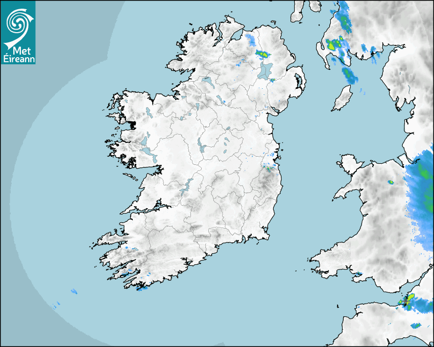

Latest Rainfall Radar showing live precipitation and the last 90 minutes precipitation over Ireland, updated every 5 minutes. Precipitation can be rain, hail or snow. Accumulations can refer to rainfall only.
Lightning strikes, when they occur, are displayed as a cross. Initially, they are red but change to orange and then yellow after a period, then disappear © Met Office ATDNet.
Ground Clutter may appear (South Co. Dublin), bright bands and spokes may also be present in images. They are artefacts (false echoes) of rainfall radar systems and should be ignored. Further information on Radar here
Met Éireann forecasters manually produce the weather icons for midday and midnight to reflect the predicted major weather type for these times.
The rainfall forecast is direct model output from Numerical Weather Prediction models but is a guideline only. Rain refers to precipitation, which can be rain, sleet or snow. It forecasts how much rain will fall (in mm) hourly during the previous hour (accumulations), then in 3 hourly and finally 6 hourly accumulations up to 7 days. This service is based on data and products of the HARMONIE-AROME and the European Centre for Medium-range Weather Forecasts (ECMWF) models.
The wind is direct model output from Numerical Weather Prediction models but is a guideline only. It forecasts the strength of the wind (in knots and km/h) at 10m for the top of each hour, in hourly, then 3 hourly and finally 6 hourly intervals up to 7 days. The wind arrow tip points in the direction the wind is blowing and the tail length indicates wind strength. However, in the text forecast below, it is described as where it is blowing from. This service is based on data and products of the HARMONIE-AROME and the European Centre for Medium-range Weather Forecasts (ECMWF) models.
The temperature is direct model output from Numerical Weather Prediction models but is a guideline only. It forecasts air temperature on land and over sea in °C for the top of each hour, 3 hourly and finally 6 hourly intervals up to 7 days. Minus zero (-0) indicates values between 0 to -0.5°C. This service is based on data and products of the HARMONIE-AROME and the European Centre for Medium-range Weather Forecasts (ECMWF) models.
The Mean Sea Level Pressure (MSLP) is direct model output from Numerical Weather Prediction models but is a guideline only. It forecasts the MSLP in hecto Pascals (hPa) for the top of that hour initially in 3 hourly intervals, then 6 hourly. This service is based on data and products of the HARMONIE-AROME and the European Centre for Medium-range Weather Forecasts (ECMWF) models.
National Forecast
16 May 2024 12:16
Today
Sunny spells will give way to thickening cloud in the east and southeast this afternoon. Showers will develop also, turning heavy with some thundery downpours giving rise to spot flooding, mainly across the midlands and south. Rain will move in from the Irish Sea this evening. Sea fog will affect some eastern and northwestern coasts at times today. Highest temperatures 18 to 21 degrees in light northerly or variable breezes, becoming moderate in the west and north this evening.
Tonight
Outbreaks of heavy and possibly rain will affect parts of Leinster and Munster, but it will be mainly dry elsewhere with a mix of cloud and clear spells. A few mist and fog patches will form also. Lowest temperatures 9 to 12 degrees in moderate northerly winds will be freshen overnight near Altantic coasts.
Tomorrow
Cloudy and misty in the east and south at first tomorrow with residual patchy rain and drizzle. Elsewhere, any mist and fog patches will give way to a mix of cloud and sunny spells. Sunny spells will gradually break through further south and east during the afternoon and evening. A few showers will develop towards evening. Highest temperatures 17 to 20 degrees but cooler in the northwest with highs of 13 to 16 degrees where the moderate to fresh northerly winds will be strongest.
Met News

02nd May 2024
Climate Statement for April 2024
Mild and wet overall April 2024 was another month ... more

01st May 2024
Government Launches Be Summer-Ready Campaign
The national ‘Be Summer-Ready’ campaign was la... more

19th April 2024
European State of the Climate 2023 & Climate of Ireland 2023
Issued Monday 22nd April 2024 Europe (From Coperni... more

19th April 2024
Daily UV Forecasts now available on Met.ie
The daily Solar UV Index level is now available wi... more